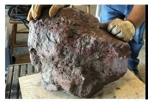
Noble Minerals Initiates Temporarily Delayed Drill Program in proximity to the Location of a 140 kg, Mineralized Boulder Found near Hearst, Ontario

(TheNewswire)
Toronto, Ontario TheNewswire – July 2, 2024 Noble Mineral Exploration Inc. ( ‘Noble’ or the ‘Company’ ) (TSX-V:NOB, FRANKFURT: NB7, OTCQB:NLPXF) is pleased to announce that after a delay due to inclement weather, Noble is now ready to initiate their drill program. Extreme hot, dry weather in mid June gave way to thunderstorms and in some cases tornadoes. Noble was concerned with potential forest fire risk and the health and welfare of their workers. With the coming of more stable weather in July, the company is now ready to start the drill program.
The drill program is planned on 214 claims in Way Township. The claims extend from about 4 to 15 km southwest of the town of Hearst, Ontario. The property area is equivalent to approximately 4,500 hectares or 45 sq km. The drill program follows geophysical surveys done to identify targets that may be the source of the mineralized boulder. The recent geophysical program was partially funded by the Ontario Junior Exploration Program and application has been made to the same program to fund the drill program. The Program will fund up to $200,000 on a $400,000 exploration program.
The mineralized boulder was on display at the highly successful Canadian Mining Expo in Timmins, Ontario in June.
Historically, a sample of a metalliferous boulder, brought to the Timmins Mining District Regional Resident Geologist in 2019 by a Mr. A. Cousineau, was submitted for chemical analysis to Geolabs in Sudbury to establish its metal and mineralogical makeup. Geolabs determined that the boulder contained: 71.8% copper; 3.5% lead, 1.09% zinc; 252 g/t of silver, 3.79 g/t of gold; 4.43 g/t of palladium; and 2.22 g/t of platinum and consisted primarily of cuprite (van Hees et al., 2020).
In 2021, Noble launched an exploration program to in an effort to identify the source of the boulder. Basal till samples collected from two fences of hand auger holes, located about 100 m and 1 km north of the boulder, produced 35 gold grains . These gold grains define a southeast-northwest trending dispersion train that indicate they were transported southeast by a glacial transport from a source area located to the northwest. The dispersion train begins near a northeast trending magnetic anomaly. The gold grains are predominantly reshaped (24) but also include modified (7) and pristine (4), supporting evidence of a local source.
In 2022 an airborne geophysical survey was flown over the property followed by a ground geophysical survey in November/December 2023. The ground geophysical surveys included 29 line-kilometers of Magnetic, VLF-EM and Induced Polarization Survey. The airborne data was successful in outlining a significant northeast trending magnetic high unit that was traced from the southwest section of the survey block to the northeast corner of the survey block. Compilation of the ground based; detailed magnetic survey was done to highlight the northwest trending fault structure that coincides with the location of the boulder. This structure extends at least 1,100 meters and is represented by a modest magnetic low signature commencing at the southeast corner of the grid. The structure can be traced across the grid, generally lying along the northern bank of the river, and has offset the modest magnetic high units in the same area. The western edge of the suspected fault terminates next to a northeast-southwest striking cross fault that also affects the strike of the river.
The approximate location of the mineralized, Cousineau Boulder appears to coincide with a slight bullseye high at the southeast end of one of the northwest striking cross dike like features. The dashed line is suggested at being a possible cross fault system . ( See Figure 1) .
The initial drill holes will be focussed in the vicinity of the boulder location in order to better understand the physical and fault related geology as defined by geophysics done in the Fall of 2023 (Figure 1). Additional drilling will be focussed on various chargeability and conductive anomalies detected during the recent ground surveys.
Click Image To View Full Size
Figure 1: Location of the boulder and initial drill holes (DDH) with identified faulting on detailed magnetic background.
Vance White, President and CEO of Noble, said ‘we are pleased with the progress on this property and to finally get underway the proposed drill program, the results of which may give us more clues as to the possible source of this rich boulder. While the odds are long, if successful, it could result in a significant find.’
Figure 2 : Photo of the Cousineau Boulder
References:
van Hees, E.H., P. Bousquet, J. Suma-Momoh, C.M. Daniels, S.L.K. Hinz, C. Boucher, P. Sword, L. Wang, S.P. Fudge, A. Millette and C. Patterson, 2020. Report of Activities 2019, Resident Geologist Program, Timmins Regional Resident Geologist Report: Timmins and Sault Ste. Marie Districts; Ontario Geological Survey, Open File Report 6366, 160p.
Wayne Holmstead P.Geo (ON), a ‘qualified person’ as defined by National Instrument 43-101, has verified the data disclosed in this news release, and has otherwise reviewed and approved the technical information in this news release on behalf of Noble.
About Noble Mineral Exploration Inc.:
Noble Mineral Exploration Inc. is a Canadian-based junior exploration company which, in addition to its shareholdings in Canada Nickel Company Inc., Homeland Nickel Inc., Go Metals Corp. and Lode Gold Resources Inc . , and its interest in the Holdsworth gold exploration property in the area of Wawa, Ontario, will continue to hold ~25,000 hectares of mineral rights in the Timmins-Cochrane areas of Northern Ontario known as Project 81, as well as an additional 20% interest in ~11,000 hectares in the Timmins area and ~175 hectares of mining claims in Central Newfoundland. Project 81 hosts diversified drill-ready gold, nickel-cobalt and base metal exploration targets at various stages of exploration. It will also hold its ~14,600 hectares in the Nagagami Carbonatite Complex and its ~4,600 hectares in the Boulder Project both near Hearst, Ontario, as well as ~3,700 hectares in the Buckingham Graphite Property, ~10,152 hectares in the Havre St Pierre Nickel, Copper, PGM property, and ~482 hectares in the Cere-Villebon Nickel, Copper, PGM property, all of which are in the province of Quebec. More detailed information is available on the website at:
www.noblemineralexploration.com .
Noble’s common shares trade on the TSX Venture Exchange under the symbol ‘NOB’.
Neither TSX Venture Exchange nor its Regulation Services Provider (as that term is defined in the policies of the TSX Venture Exchange) accepts responsibility for the adequacy or accuracy of this release. No stock exchange, securities commission or other regulatory authority has approved or disapproved the information contained herein.
The foregoing information may contain forward-looking statements relating to the future performance of Noble Mineral Exploration Inc. Forward-looking statements, specifically those concerning future performance, are subject to certain risks and uncertainties, and actual results may differ materially from the Company’s plans and expectations. These plans, expectations, risks and uncertainties are detailed herein and from time to time in the filings made by the Company with the TSX Venture Exchange and securities regulators. Noble Mineral Exploration Inc. does not assume any obligation to update or revise its forward-looking statements, whether as a result of new information, future events or otherwise.
Contacts:
H. Vance White, President
Phone: 416-214-2250
Fax: 416-367-1954
Email: info@noblemineralexploration.com
Investor Relations: ir@noblemineralexploration.com
Copyright (c) 2024 TheNewswire – All rights reserved.
News Provided by TheNewsWire via QuoteMedia


